However, almost in sight is the 'next beginning' of the bike path, on the other side of an old rail road bridge past the Shaw's supermarket and across Main Street.
The detour from this ending of the bike path - following the Cross VT Trail - all the way over to State Street, past the busiest intersection in all Montpelier and down Main Street to the (theoretical) continuation of the bike path is unnecessary.
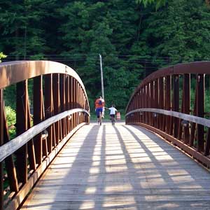
And it needs to change. As one can see on the picture of the rail road bridge by Shaw's (on the left), there is a narrow 'walkway', on the left side made of wooden planks, however no rail on the right side, and officially not a walkway (indicated by 'Do not enter' signs as of lately). This bridge still does serve many people every day as a crossover and connector from the parking lots behind the buildings on the southern side of State Street to Shaw's, Barre Street and Main Street and mostly the bike path out towards Hunger Mountain Coop.
What does it take to make this bridge safe for pedestrians, runners, cyclists, walkers... and connect the 'two separate pieces of bike path' in Montpelier?
And after all, have the recent reconstruction of the Bike/Pedestrian Bridge make sense!
No comments:
Post a Comment